There are hundreds of millions of possible sea route alternatives. Calculate distance, time, and bunker consumption from any of the vessels' real-time AIS positions to more than 10,000 ports, or between ports, with draggable waypoints, alternative sea routes per main sea route, canal constraints, ice and consecutive sea route planning.
Create sea routes from a vessel’s live AIS position or from port to port, and calculate the distance, ETA, days at sea, fuel consumption, and minimize the EU ETS costs.
Compare different sea route options, such as sailing around the Cape of Good Hope or via canals. Find the best option for you by toggling off/on avoid canals, avoid ice, or minimize sailing time in ECA zones.
Compare the calculated sea routes with the actual sailed sea routes for specific vessel sizes.
Find bunker ports along your route, with daily updated prices, available bunker grades, and forward curves.

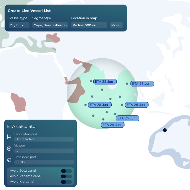
From one view you can create several sea routes from a current AIS position to several ports. So if you have fixed UK/CONT/ MED incl. France you can find when your vessel will be open in ports included in these areas.
In case you might need bunkers to reach some of these destinations, you can toggle on the bunker ports along the sea routes for all these optional ports, and find daily updated bunkers and grades offered in the ports.
Useful if you want to find the distance from a vessels AIS position to the nearest land, between two vessels, or for STS, emergency and rescue operations. Just click in the map and create the distance calculator.

ShipIntel Essentials is an AI-powered maritime decision support system for any type of company and teams involved in maritime business so they can reduce manual work, create more business and provide better service based data-driven insight.
We decided to change over to ShipIntel because it is a great and user-friendly ship tracking system with so much more. With over 50 vessels in our ship project finance portfolio, we need ship details, alerts, port info, traffic statuses and trends all the time. ShipIntel is a tool that easily gives us such information and connects our team.

ShipIntel is our go-to solution for portfolio monitoring. ShipIntel is a reliable software built on high-quality data, followed by excellent customer and user service. Exactly what we need to gain real-time insight to empower our team's strategic decision-making.

Having used several competing AIS providers, we were confident in our decision to add ShipIntel Essentials to our toolbox. We are impressed with its sleek, responsive, and easy-to-use interface and we're excited to leverage its full potential in our day-to-day operations. Maritime Optima has been very attentive, listening to our needs and implementing functions we have requested.

We started using ShipIntel because we needed an AIS software and a sea route calculator. We added more features because we gained access to high-quality AIS data, smart AI searches, and a very user-friendly software at an affordable price. There are too many stand alone softwares, and we have started looking for a kind of all in one software that gives us what we need at an affordable price.
We chose ShipIntel because it is an innovative solution, easy to use, and comes with a very competitive price. We continued using ShipIntel because the Maritime Optima team continuously develop and maintain the software. We also think it is an advantage that maritime software is developed by people that have been working in the industry. So the easy to use, relevancy, high AIS quality and price makes ShipIntel a unique maritime software box.

We believe ShipIntel stands out on key points such as coverage, search/filters/lists, and user interface. The highly skilled IT team is supplemented with experienced shipping people, so we are confident that ShipIntel will continue developing to our benefit.

