For any type of company involved in maritime business.
ShipIntel Essentials delivers essential maritime features built on high-quality, real-time and historical AIS data, along with other publicly available maritime data.
You and your team can seamlessly integrate your private data, while keeping it fully secure and confidential. All through a user-friendly design with easy-to-use call-to-action features.
Plan smarter. Work more efficiently. Deliver better service.
Too many stand-alone software tools and data subscriptions lead to constant context switching, wasted time, duplicated work, and costly licensing fees and IT consultants.
Producing trustworthy, actionable business insight and automation requires well-structured data trained in a maritime context. To unlock your AI potential, look for a seamless solution at an affordable price.
People matter. Together, structured data, AI, and people create breakthroughs. Foster collaboration that challenges assumptions, uncovers blind spots, and drives high-value insight.
Turn high-quality, real-time and historical AIS data along with other publicly available maritime data into real business value. Seamlessly integrate your private data while keeping it fully secure and confidential, for more relevant, actionable insights.
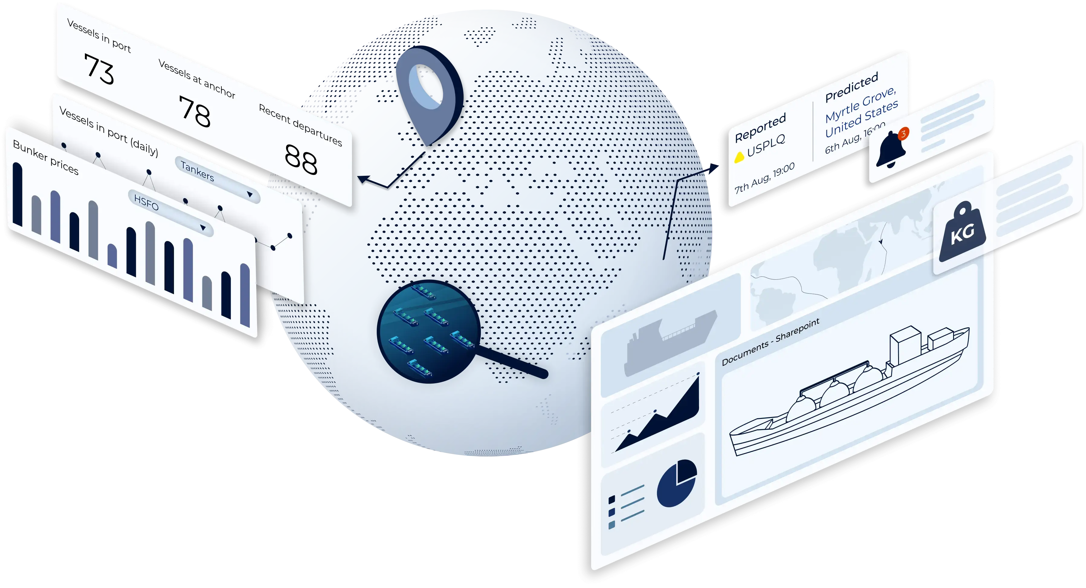
Knowing what's happening and what has happened at anchorages and in ports puts you in a better position to reduce costs, spot opportunities, and make smarter investment decisions. ShipIntel Essentials gives you an overview of vessel movements in areas, regions, at anchorages and in ports.
You know what you're looking for and vessel lists are created for different reasons. ShipIntel Essentials makes it easy to find and group vessels you are looking for based on dynamic operational criteria, technical descriptions, email correspondence, or a combination of different data sources.
There are hundreds of millions of possible sea route alternatives, our sea routing engine enriched with historical and real-time AIS data, machine learning models, vessel-specific routing intelligence, and constraint-based optimization helps you find distances, time, ETAs, EU ETS costs, along with alternative sea routes per main route. Consecutive sea route planning, canal constraints, ice conditions, vessel restrictions. From any vessel's real-time AIS position to any port, or between ports.
ShipIntel is not “yet another email client.” ShipIntel is a maritime intelligence workspace where emails are turned into connected, structured maritime intelligence, with actionable data linked to vessels, ports, cargoes, companies, contacts, calculations, fixtures, schedules, voyages etc.
ShipIntel Essentials is a holistic maritime software solution with essential, easy-to-use features, including: AIS-based tools, sea routes with bunkering and EU ETS calculations, daily updated bunker prices, email parsing and management, quick voyage calculations, and vessel and port list insights with tailor-made notifications. All features are built on well-structured data trained in a maritime context, unlocking your AI potential.
Explore ShipIntel through a live personalized demo where you ask the questions and we show you how to find the answers by using ShipIntel Essentials.

We decided to change over to ShipIntel because it is a great and user-friendly ship tracking system with so much more. With over 50 vessels in our ship project finance portfolio, we need ship details, alerts, port info, traffic statuses and trends all the time. ShipIntel is a tool that easily gives us such information and connects our team.

ShipIntel is our go-to solution for portfolio monitoring. ShipIntel is a reliable software built on high-quality data, followed by excellent customer and user service. Exactly what we need to gain real-time insight to empower our team's strategic decision-making.

Having used several competing AIS providers, we were confident in our decision to add ShipIntel Essentials to our toolbox. We are impressed with its sleek, responsive, and easy-to-use interface and we're excited to leverage its full potential in our day-to-day operations. Maritime Optima has been very attentive, listening to our needs and implementing functions we have requested.

We started using ShipIntel because we needed an AIS software and a sea route calculator. We added more features because we gained access to high-quality AIS data, smart AI searches, and a very user-friendly software at an affordable price. There are too many stand alone softwares, and we have started looking for a kind of all in one software that gives us what we need at an affordable price.
We chose ShipIntel because it is an innovative solution, easy to use, and comes with a very competitive price. We continued using ShipIntel because the Maritime Optima team continuously develop and maintain the software. We also think it is an advantage that maritime software is developed by people that have been working in the industry. So the easy to use, relevancy, high AIS quality and price makes ShipIntel a unique maritime software box.

We believe ShipIntel stands out on key points such as coverage, search/filters/lists, and user interface. The highly skilled IT team is supplemented with experienced shipping people, so we are confident that ShipIntel will continue developing to our benefit.

